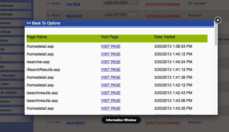
Real Estate Term:Dominion Land Survey
The Dominion Land Survey is the method used to divide most of western Canada into one-square-mile sections for agricultural and other purposes. It is based on the layout of the Public Land Survey System used in the United States, but has several differences. The DLS is the dominant survey method in the Prairie provinces, but it is also used in British Columbia along the Railway Belt (near the main line of the Canadian Pacific Railway), and in the Peace River Block in the northeast of the province. The survey was begun July 10, 1871, shortly after Manitoba and the North-West Territories became part of Canada. Covering about 800 000 square kilometres, the survey system and its terminology are deeply ingrained in the rural culture of the Prairies.
The most important north�south lines of the survey are the meridians:
The First (or Principal) Meridian at 97�27'28.41? west, just west of Winnipeg, Manitoba.
The Second Meridian at 102� west, which forms the northern part of the Manitoba�Saskatchewan boundary.
The Third Meridian at 106� west, near Moose Jaw and Prince Albert, Saskatchewan.
The Fourth Meridian at 110� west, which forms the Saskatchewan�Alberta boundary and bisects Lloydminster.
The Fifth Meridian at 114� west, which runs through Calgary, Alberta (Barlow Trail is built mostly on the meridian) and near Stony Plain, Alberta.
The Sixth Meridian at 118� west, near Grande Prairie, Alberta and Revelstoke, British Columbia.
The Seventh Meridian at 122� west, between Hope and Vancouver, British Columbia.
The main east�west lines are the base lines. The First Base Line is at 49� north, which forms much of the Canada�United States border in the West. Each subsequent base line is slightly more than 24 miles (about 39 km) to the north of the previous one.
Starting at each intersection of a meridian and a base line and working west (also working east of the First Meridian), nearly square townships are surveyed, which are about six miles (9.8 km) in both north�south and east�west extent. There are two tiers of townships to the north and two tiers to the south of each base line.
Because the east and west edges of townships (range lines) are meridians of longitude, they converge towards the North Pole. Therefore, the north edge of every township is slightly shorter than the south. Only along the base lines do townships have their nominal width from east to west. The two townships to the north of a base line gradually narrow as one moves north, and the two to the south gradually widen as one moves south. Halfway between two base lines, wider-than-nominal townships abut narrower-than-nominal townships. The east and west boundaries of these townships therefore do not align, and north�south roads that follow the survey system have to jog to the east or west. These east�west lines halfway between base lines are called correction lines.
Townships are designated by their township number and range number. Township 1 is the first north of the First Base Line, and the numbers increase to the north. Range numbers recommence with Range 1 at each meridian and increase to the west (east of First Meridian they are numbered eastward). On maps, township numbers are marked in Arabic numerals, but range numbers are often marked in Roman numerals; however, in other contexts Arabic numerals are used for both. Individual townships are designated such as "Township 52, Range 25 west of the Fourth Meridian," abbreviated "52-25-W4." In Manitoba, the First Meridian is the only one used, so the abbreviations are even more terse, e.g., "3-1-W" and "24-2-E."
|